For futher project details, visit our Github! https://github.com/whereswelly-govhack/wheres-welly
Project Description
Why we chose to do this:
We set out to save people from the pain we’ve experienced when buying, renting and booking accommodation in Wellington. We love Wellington but it’s weird. Due to its hills, layout, and public transport quirks things can be further away or closer than they seem.
Where's Wally is a tool to help current and prospective Wellingtonians plan where to live and explore in the windy city. If you are planning on moving in and want somewhere close to work, you can use Where's Wally to help you find where is best for you.
What it does:
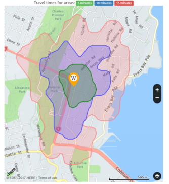
At Where's Welly, users can mark their work and home locations, and gain useful statistics about travel times by vehicle, by foot as well as recent rent statistics, courtesy of MBIE. Regions are mapped to indicate 5, 10 and 15 minute travel time from the work location.
Looking for Home
Users with a fixed work location who are looking for where to live can set their markers like this. Khandallah (marked "H" on the map) might look close on the map, but in terms of travel time you would be better off living further away.
Where's Welly also displays the following:
- Travel time by foot, bicycle or vehicle
- Basic accomodation, fuel and parking costs for getting to and from your work location

It is also possible to plot regions based on walking distance. If you simply want to take a walk and see how far is too far, Where's Welly will help you do that too.
Looking for Work
For users with a fixed home or school location who are looking for work in Wellington can set their markers like this. This way, the tool will tell you which parts of Wellington are most accessible (and cheap!) from where you live.

Who it's for
-
Home buyers priced out of areas they know, looking for good value homes
-
Students and Renters looking for somewhere to live within easy walk of the things they want to do
-
Visitors
-
Would be retirees
-
Exercisers working out walking or running routes
-
Business people finding places to meet or locate a co-working space
Data Story
Where's Welly was developed in JavaScript using the HERE API, and a considerable amount of open government data, provided by Stats NZ, Ministry of Business, Innovation and Employment (MBIE).
The source code is provided here with a Something-or-other License. Our datasets are also provided for the benefit of developers as well. They have been collected from various open data sources, and are in /data in raw and edited form.
Datasets
A more detailed breakdown of the datasets used is here:
- HERE API
- Mapping System, iso-chrones
- Stats NZ
- New Zealand regional and area unit maps
- Ministry of Business, Innovation and Employment
- Median rental costs by area unit
- Education Counts
- NZ School location data + additional info
Future Goals
Future development goals include:
- Better capturing public transport options
- Adding more layers of services
- Building on the happiness and self-assessed health scores from the Human Health Survey
- Adjusting the scale to match commuting preferences
- Integrating with existing rental and house sales websites so that their information is more useful.
Many Thanks
Many thanks to the HERE team, our data contributors, including the folks at data.govt.nz and of course, the team at Govhack Wellington 2017 for keeping us well fed and watered through a busy 46 hour period.
Prize Eligibility
Best use of open government data combining HERE location capabilities (API, SDK) to solve a tourism challenge
Tourists who are fresh to Wellington city have a lot of options about where to stay, but it can be tricky to figure out which parts of the map are close or far from where. If they know they will be spending time in the CBD, Where's Wally is a tool that will help show them which parts of Wellington are accessible and which are not. For example, they might not consider looking for cheaper accomodation in the Hutt Valley because it looks quite far on a map, but Where's Wally can show this sort of information to them.
Where's Wally also notes the locations of key tourist sights & museums, shops, cafes, restaurants and entertainment.
Best geo-spatial (location) use of open government data combining HERE location capabilities (API, SDK)
The key feature of the tool (the coloured regional maps, called isochrones) is created using the HERE API. Other location data, such as cafe locations, sights and museums etc are also created using the HERE APIs also.
